Census Data Aggregation Tool
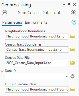
For my final project for GEOG 485, GIS Programming and Software Development, I created a spatial aggregation tool, which takes data from smaller areas (census tracts) and sums it into larger neighborhood tracts. The output is a new feature class of neighborhood boundaries with an added field that provides the data sum for each neighborhood.
Future improvements would allow the user to select multiple (or all) data fields to be calculated for each neighborhood, and add these to the neighborhood boundaries feature class within a single run of the tool.
This tool could be used to sum data from any feature class with smaller polygons that have their center within larger polygons from a separate feature class.
You can view the code here.